


Themenweg Forst und Jagd

SityTrail - itinéraires balisés pédestres
Tous les sentiers balisés d’Europe GUIDE+
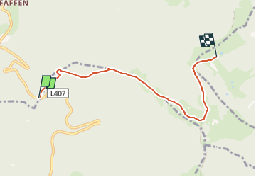

Length
5.4 km

Max alt
1537 m

Uphill gradient
244 m
Km-Effort
8.4 km

Min alt
1298 m

Downhill gradient
179 m
Boucle
No

Signpost
Creation date :
2022-02-16 17:20:43.809
Updated on :
2022-03-03 19:23:49.498
1h54
Difficulty : Easy

FREE GPS app for hiking
 SityTrail
IGN / Geographical institutes
SityTrail Plus
The world is yours!
About
Trail On foot of 5.4 km to be discovered at Lower Austria, Bezirk Neunkirchen, Gemeinde Trattenbach. This trail is proposed by SityTrail - itinéraires balisés pédestres.
Description
hat mit Forst und Jagd wenig zu tun, aber heißt halt so
Photos


Positioning
Country:
Austria
Region :
Lower Austria
Department/Province :
Bezirk Neunkirchen
Municipality :
Gemeinde Trattenbach
Location:
Unknown
Start:(Dec)
Start:(UTM)
565092 ; 5268600 (33T) N.
Comments